Introduction
This lab is a two-part lab. The first part is setting up and pre-flighting the Bramor C-Astral fixed wing UAV. The second part of the lab is working with the mission planning/monitoring software that the C-Astral utilizes.
Pre-Flight Checklist
The first part of pre-flighting comes before leaving the office. The included checklist book actually has a section called the Office Checklist. This checklist allows the pilot to ensure that every part of the flight kit is included in the case, batteries, tablet, and ground control station are charged, and that in general nothing has been left behind. Sometimes jobs can have flights that are an hour or more drive away, this checklist just helps the POC make sure that they haven't wasted half a day driving around only to realize they left something behind.
The actual pre-flight of this aircraft is incredible strict and specific. It is a very expensive aircraft, therefore you would not want anything to go wrong. Following the checklist word for word and line by line is of the utmost importance. A big part of the pre-flight is your Crew Resource Management (CRM). Teams of four typically fly the C-Astral, and every person has their role. While tasks can be divided up however the group sees fit, our group followed this guide:
- Pilot in Command (POC) reads checklist
- Secondary pilot challenges the POC by making sure each step has been completed successfully before moving on
- Visual Observer (VO) helps the equipment manager with anything they need help with, many of these steps are a two person job
- Equipment Manager carries out the tasks along with the VO
Due to the extensiveness of the pre-flight cheklist, I will only be covering a few important steps here. These are not necessarily in order, nor are they necessarily the most important steps, or all of the important steps, but these steps are important.
- Camera SD card is inserted and formatted
- All batteries are fully charged and seated in the aircraft firmly
- Catapult is properly setup and fully locked
- Catapult pin is inserted
- Antenna should be properly attached prior to the GCS being turned on
- The GCS should not be turned on near the antenna
- Flight controls should be tested in hand prior to take-off
- Mission has been designed, uploaded, and checked for accuracy at waypoints
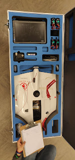 |
| Figure 1: Top half of the carrying case |
Working with the Software
First, we were asked to draw an area mission at the Bramor Test Field. This is a quick process, simply hit the Draw box on the right side bar, then Area Pts, and click the areas where you would like the mission to be. Figure 2 below shows the 3D view of the test field mission.
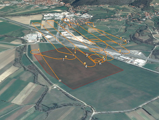 |
| Figure 2: 3D View - Bramor Test Field |
The next mission to be drawn was a corridor mission along the road nearby the test field. This process is completed again by hitting the Draw box in the side bar, but then utilizing the Street Pts drawing tool. Figure 3 shows the corridor mission. The mission centers on the road and takes images on both sides of it as well to get a better overlap.
 |
| Figure 3: 3D View - Corridor Mission |
The third mission I was asked to complete was at the County Amphitheatre Park in West Lafayette. Figure 4 below shows the flight plan created for this mission, and figure 5 shows the winds coming from the southwest.
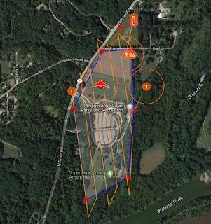 |
| Figure 4: Amphiteatre Park Flight Plan |
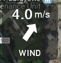 |
| Figure 5: Winds from SW |
The last mission we were tasked to create was "an agricultural area in the world with mountainous terrain." I chose an area of the Rocky Mountains in Canada. The mission plan is shown from an oblique angle parallel to the path of travel, and an oblique angle perpendicular to the path of travel. These are shown in figure 6 and 7.
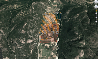 |
| Figure 6: Parallel view of mountain mission |
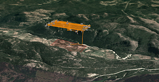 |
| Figure 7: Perpendicular view of mountain mission |
Conclusion
The mission planning done using C3P is very important, as are the pre-flight checks. The Bramor C-Astral is a very high tech, very expensive aircraft, therefore ensuring pre-flight goes smoothly and everything is done by the book will allow for safe, unhindered flight. Mission planning is a very important part of the pre-flight as well. As seen in figures 6 and 7, there is mountainous terrain on both sides of the mission. Checking the surroundings of the aircraft, and making sure to avoid any obstacles such as terrain changes, trees, and power lines are all keys to success when operating the C-Astral.


Comments
Post a Comment