Posts

Showing posts from February, 2019

Processing Data in Pix4D with Ground Control Points
Image
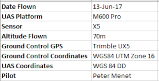
Introduction In this lab ground control points are utilized to help make our final outputs more accurate, and reduce some of the distortions that can exist without GCPs. GCPs are specific locations in the surveyed area that have a known coordinate allowing for more accurate location calibration within the software. The fact that the GCPs have known coordinates will increase the quality of our output tremendously by being able to more accurately organize the surrounding images based on their proximity to the ground control point. Checkpoints can also be used to help increase the quality of a product. While ground control points are used as a georeference for the product, checkpoints simply check accuracy of the model by showing the percent error of the images. Methods  The metadata for this specific flight is shown in figure 1 below. Figure 1: Flight metadata  As with some of the previous labs, based on the specific sensor used for the flight, the shutter type m...

Processing Data in Pix4D Without Ground Control Points

Image
Introduction What is Pix4D? Pix4D is a photogrammetry software often used with UAS data for 3D mapping purposes.  What products does it generate? Pix4D can be used to create orthomosaic images, terrain and surface models, animated flight paths, and more. These generations require imagery to have at least a 75% frontal overlap, and a 60% side overlap (in more uniform fields these percentages jump up to 85% and 70% respectively). Both nadir and oblique images can be used. However, with oblique images, the sensor angle must be between 0 and 45 degrees and pointing in both track to the center of the corridor. Additionally, multiple flights can be processed together as long as the images have the proper amount of overlap, and meteorological conditions are fairly similar. Ground control points can be used, but are not required, in Pix4D. They can be used as a georeference for the images which will help reduce some of the noise and distortion that can occur in data processing. ...

Point Cloud, Orthomosaic, and DSM Creation using ArcPro

Image
Introduction What is photohrammetry? Photogrammetry is utilized with mapping to help measure distances between objects and defining the location of a point in space. What types of distortion does remotely  sensed imagery have in its raw form? Distortion occurs in remotely sensed imagery due to the fact that a two-dimensional image is being taken of a three-dimensional object. Objects seen directly from above will have no depth, whereas objects far from the center of the lens will appear to ben outward slightly. This problem becomes more noticeable the further away from the center of the image the object is. What is orthorectification? What does it accomplish? Orthorectification is a process that attempts to remove the negative effects (distortion as mentioned above) of an image. It can solve the issue of the tilting that happens in images to create a correct, more accurate representation of the space. ...